The Somersetshire Coal Canal September 2022

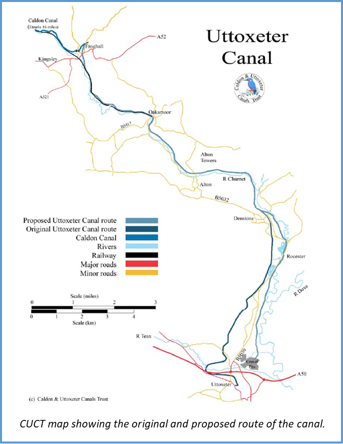
The weekend started on Friday evening when we were met by Derrick Hunt and Patrick Moss from the Somersetshire Coal Canal Society who gave us an excellent talk about the history of the coal canal.

The name of the canal is self-explanatory, it was built to transport coal from the Somerset coalfields of Timsbury, Paulton and Radstock to Bath, Wiltshire and beyond. Coal had been dug in the area since the 15th century; by 1680 pits had been opened in the Paulton area and in Radstock in 1763. In the period 1680-1690 the Paulton pits were producing 100,000 tonnes per annum but transportation of the coal to the Bath area was difficult and expensive. There was serious competition from Pontypool coal as this was cheaper to transport to Bath. The solution was to build the 10½ mile canal from Timsbury and Paulton basins to Monketon Combe to join the Kennet and Avon canal at Dundas Aqueduct.

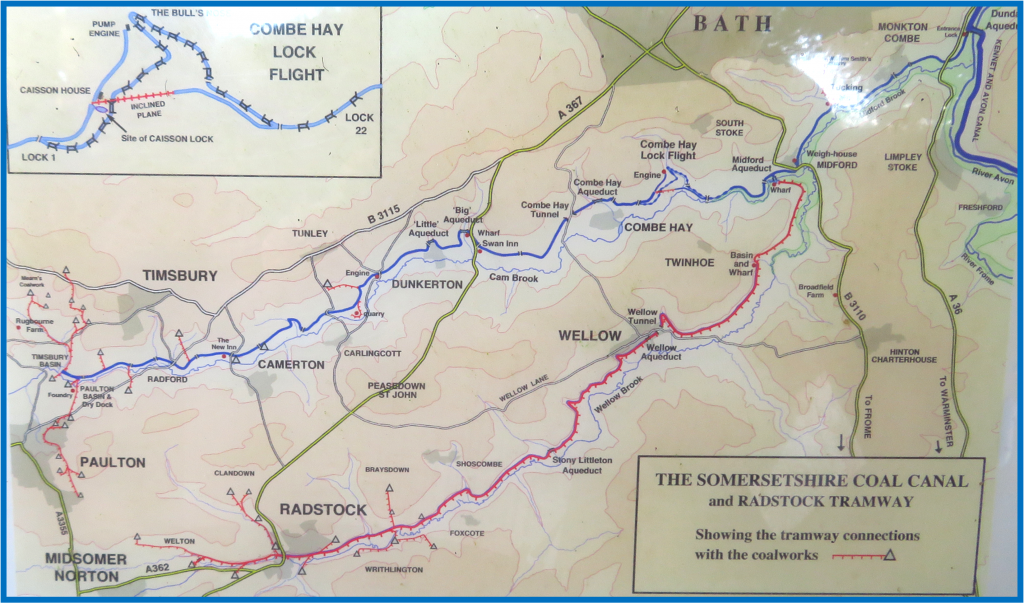
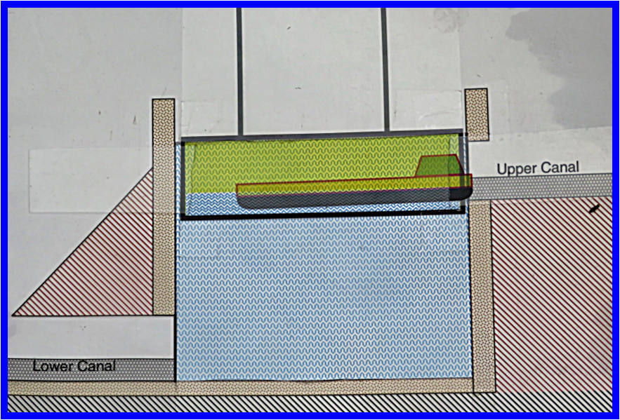
After a stop lock at Monkton Combe the canal ran level until it had passed through Midford then it had to be raised 135 feet to it’s summit level. A flight of 3 caisson locks were the first solution, a boat was floated into a water tight caisson completely submerged in a water filled masonry chamber about 50 feet deep where it could be floated up or down, saving water.

This system soon failed and was replaced by a gravity operated inclined plane which moved loaded carriages carrying boats between the bottom and top. Finally, a flight of 22 locks was built around a very tight bend in the hillside.

The canal was complete by 1805 and was very successful. Between 1812 and 1823 transported coal rose from 66,000 tonnes to 106,000 tonnes per annum and by 1858 this had risen to 165,000 tonnes per annum (over 8000 loaded boats).  However, with railway competition by 1892 the tonnage had dropped to just 17,000 tonnes per annum and in 1893 the canal company went into liquidation. On 11th November 1898 the pumps at Dunkerton were decommissioned and the canal closed, after which the canal was bought out by the Great Western Railway. 

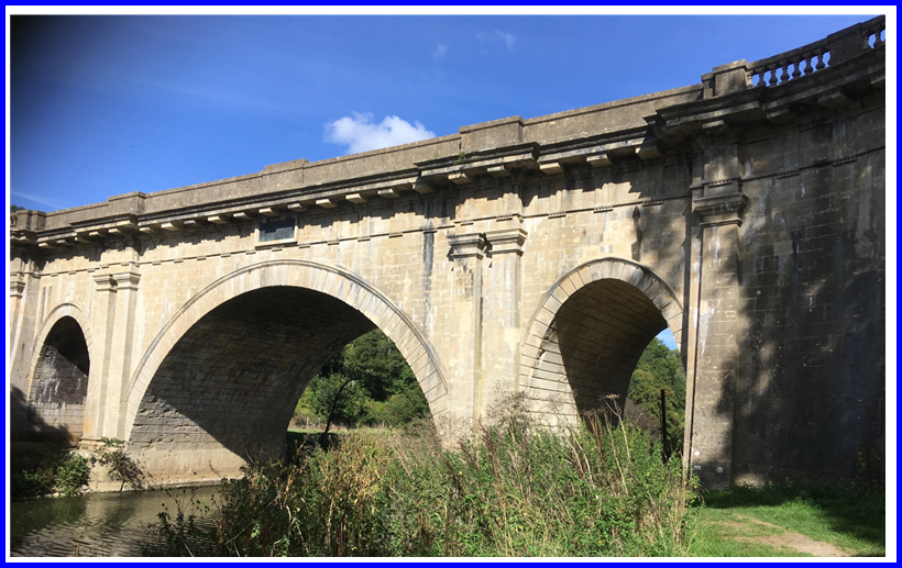
Bath stone which is used for much of the old building in the area is very prone to frost damage. It is very porous and must be laid in the same orientation as it was in the ground (ie. top to top) to allow water to drain freely, otherwise frost damage occurs, clearly visible on many old structures, including Dundas Aqueduct.

The Somersetshire Coal Canal Society was formed in 1992 ‘to research, document and preserve the canal’ and have been busy restoring sections and preserving the line for future restoration.

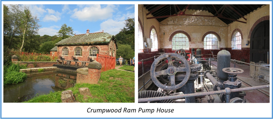
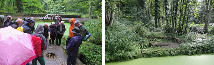
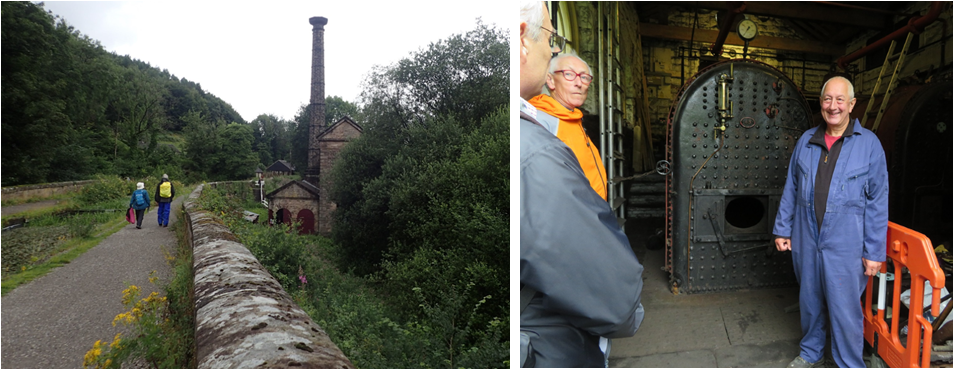
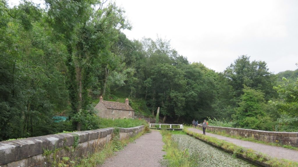
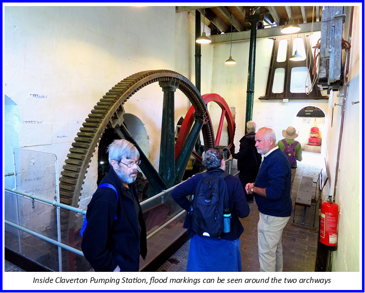
On Saturday morning were met by Liz Tuddenham , who was to be our guide for the day, at the Somerset Coal Canal Visitor Centre at Monkton Combe. This is situated on the coal canal about 500 metres from the junction with the Kennet & Avon. Before setting off along the coal canal though, we walked along the Kennet & Avon to Claverton Pumping Station where we were given an excellent tour by Julian Stirling and his team along with former volunteer Neil Hardwick.

Originally a mill site, Claverton was the second pumping station on the Kennet and Avon. Crofton supplies water to the highest level of the canal but a second pumping station was needed at Claverton to top up the canal which had frequent leaks and the need to supply the Bath flight of locks.

These two excellent videos show the working of the pumping station:

Unfortunately the building floods every winter – some of the higher flood levels are marked around the archways inside – and soon after our visit the volunteers would be preparing it for the winter with the prospect of cleaning the silt out yet again next year.

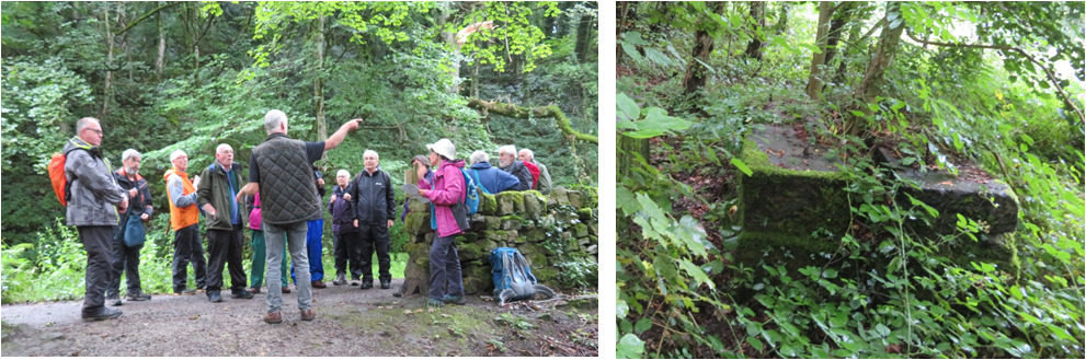
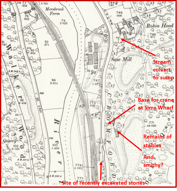
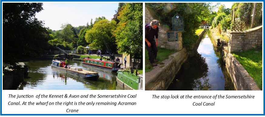
Retracing our steps along the Kennet and Avon we stopped to admire the last surviving example of an Acramans Crane situated at Dundas Wharf next to the junction with the Somersetshire Coal Canal. This was used to lift cargo and stone weights for calculating toll charges.

The entrance to the Coal Canal originally had a stone bridge which is long gone, an aluminium lift bridge was sourced to replace it. The stop lock had an extra gate in the centre of the lock which would close if levels dropped, to preserve the level on the Kennet and Avon canal. There is a theory that this was originally a wide lock as when it was excavated the  invert of the lock was found to have a distinct slope from one side to the other, rather than sloping down to the centre as would be expected with a narrow lock. This may explain the possible position of a crane base at the far left corner of the original lock for lifting wide stop planks.

Before leaving the Kennet and Avon we had to stop and admire Dundas Aqueduct, completed by John Rennie in 1810 and now a Scheduled Ancient Monument.

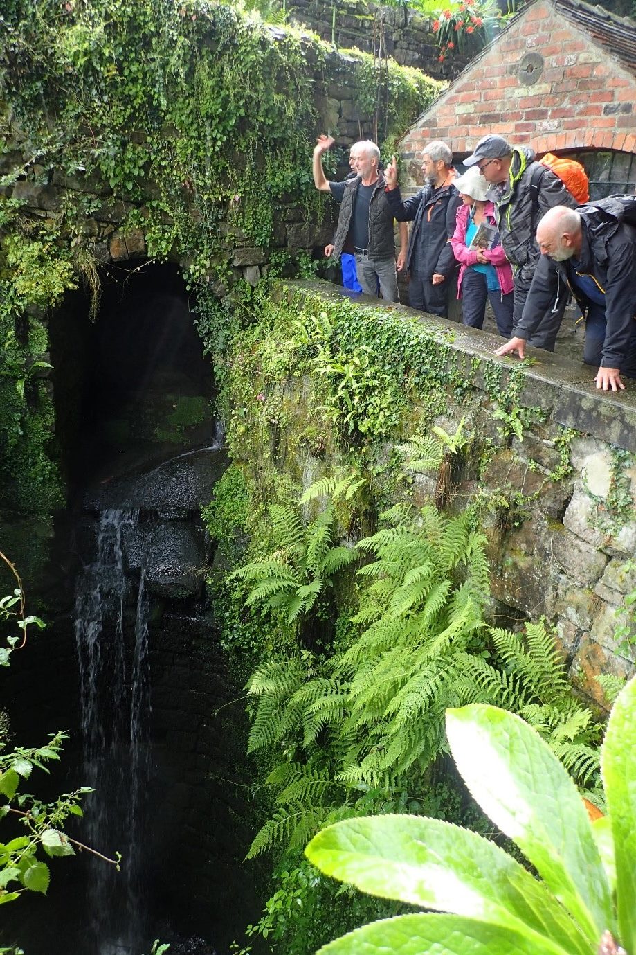
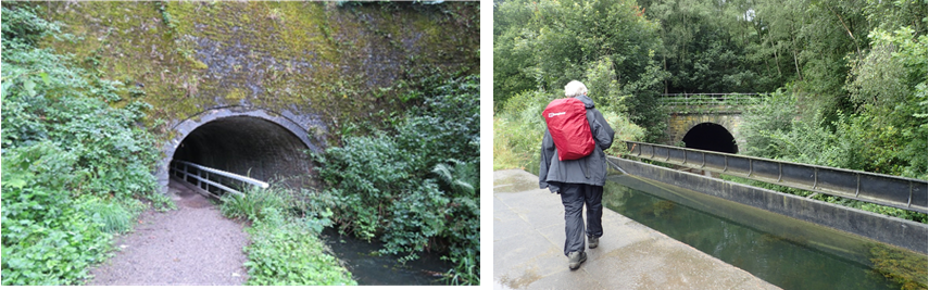
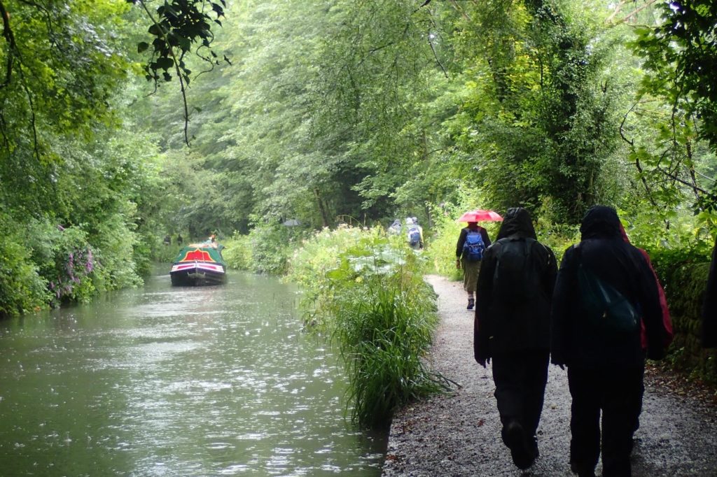
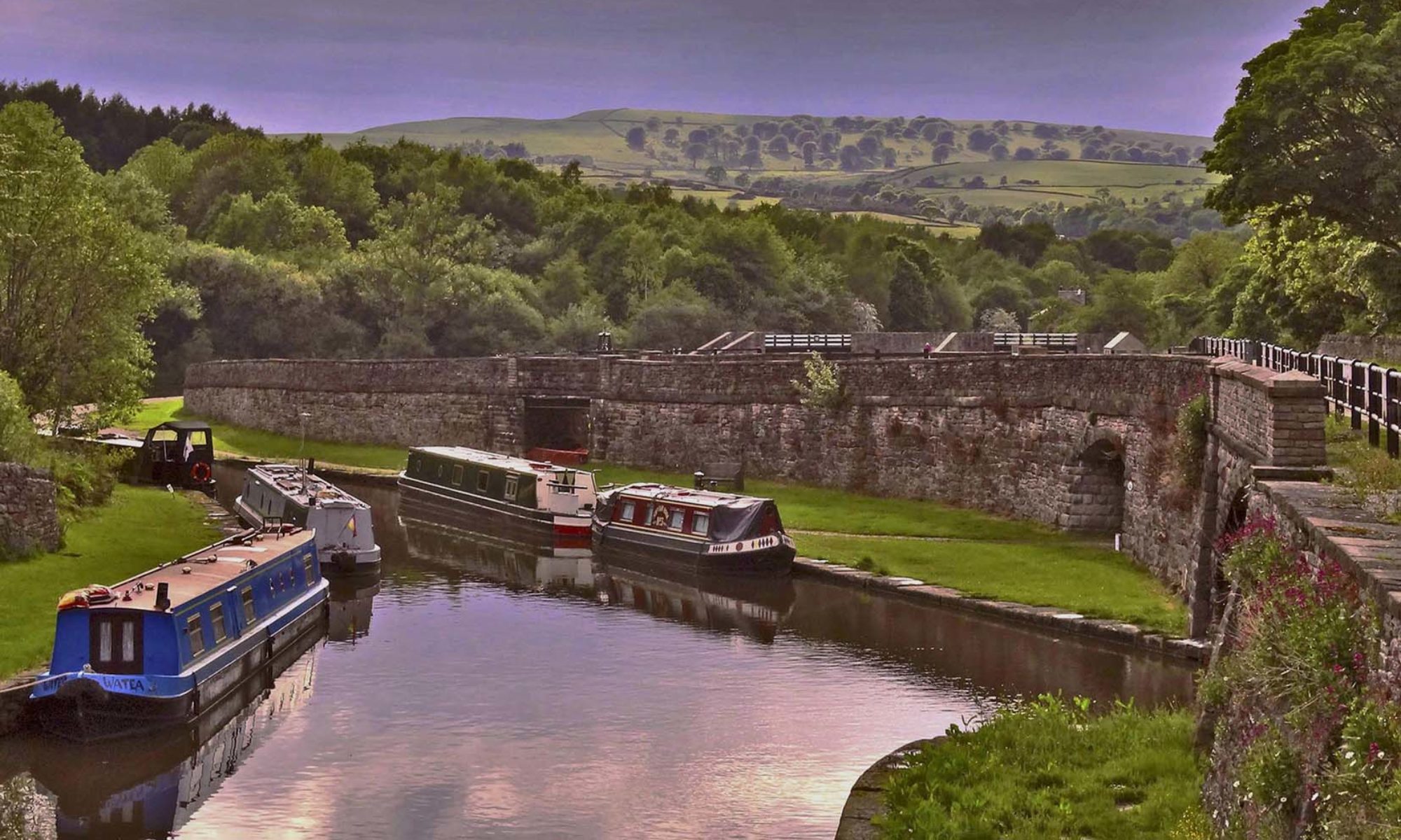
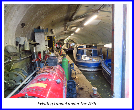
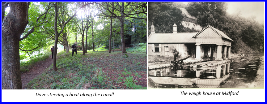
We now joined the Somersetshire Coal Canal. The first section is in water and used by a boat business so a slight detour has to be taken around moorings. After the moorings is the visitor centre and café providing welcome refreshments. From here we started the afternoon’s walk to just beyond Midford. The in-water section finishes just beyond the visitor centre where it goes into a tunnel under the main road. The other end of the tunnel is blocked and the tunnel is currently being used as a wet dock.

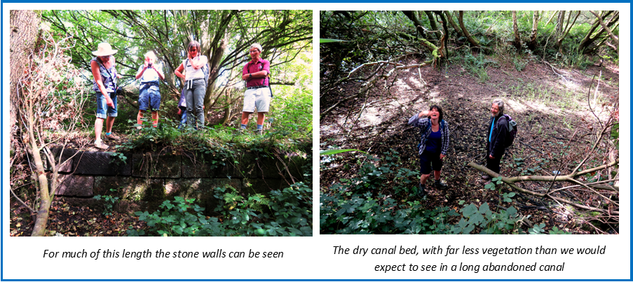
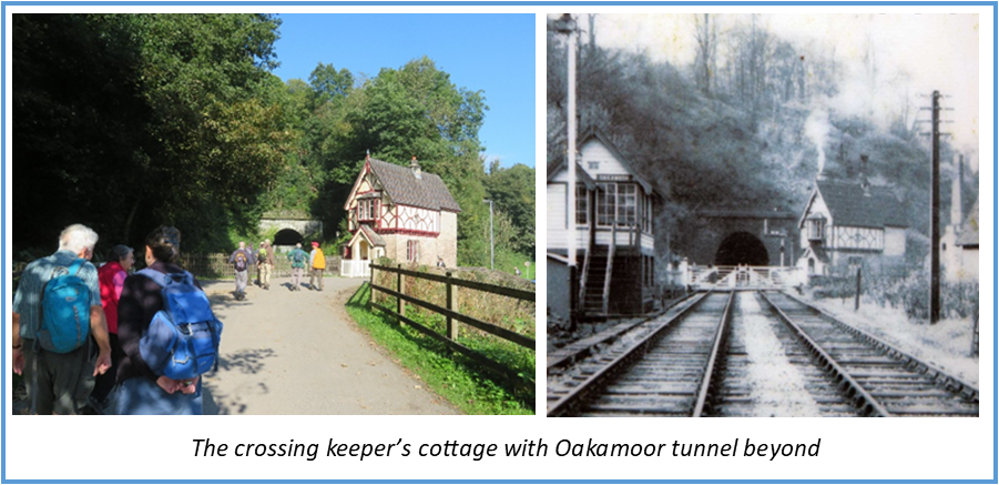
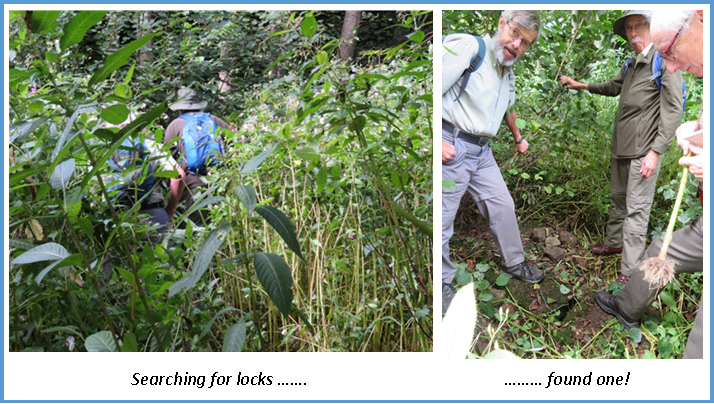
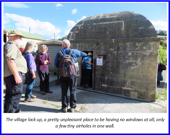
Then next section of the canal is dry and various diversions have to be made. Immediately after the tunnel the Limpley Stoke to Camerton Railway cut through the canal, effectively cutting off most of the canal from the rest of the system. The footpath kept crossing the line of the canal until we reached the village of Monkton Combe where we diverted through the village. Luckily we found the village lock up was open for viewing so this provided an interesting diversion.

From here we followed the road to Tucking Mill, a small hamlet that had a wharf next to the mill. The hamlet is where William Smith, ‘father of English Geology’, lived after surveying the line of the canal, the blue plaque is placed on the wrong house in the hamlet!

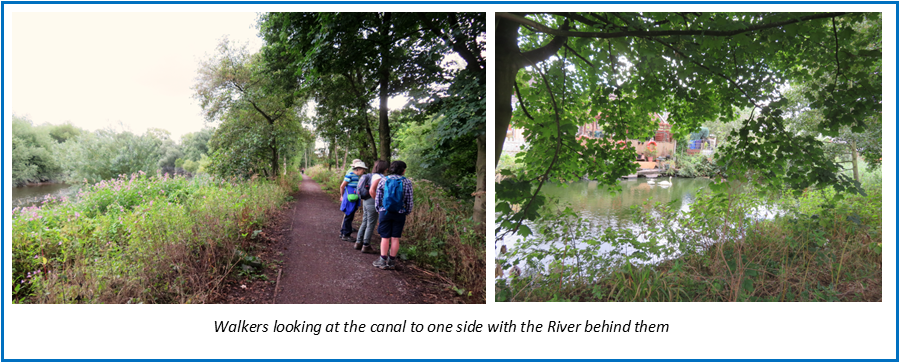
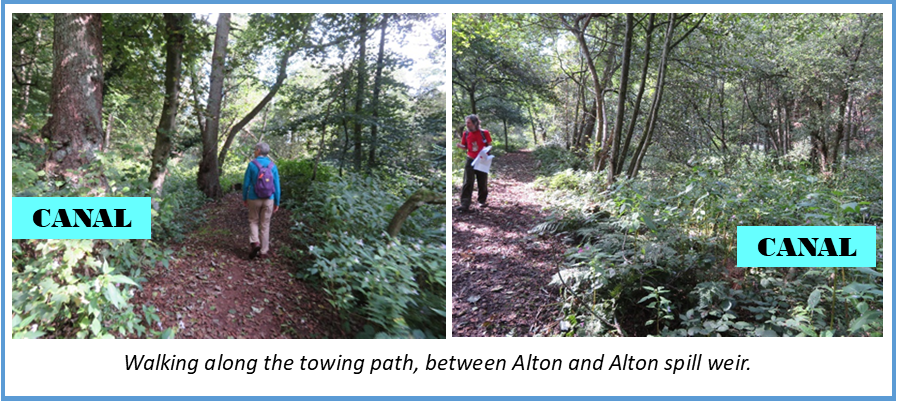
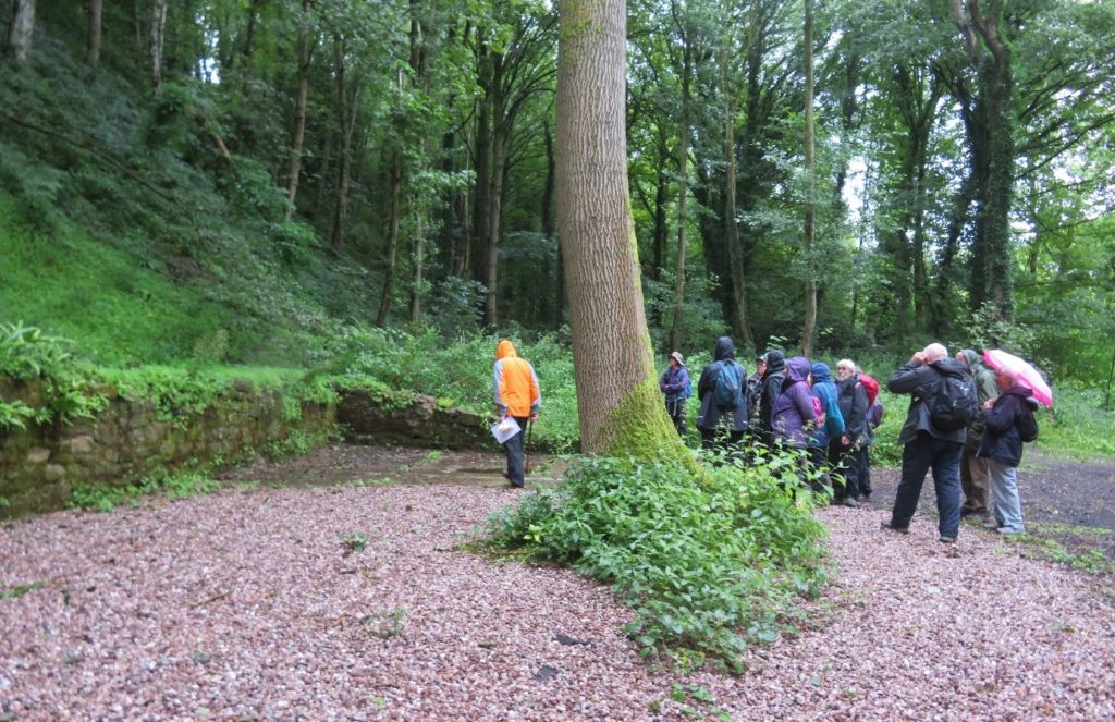
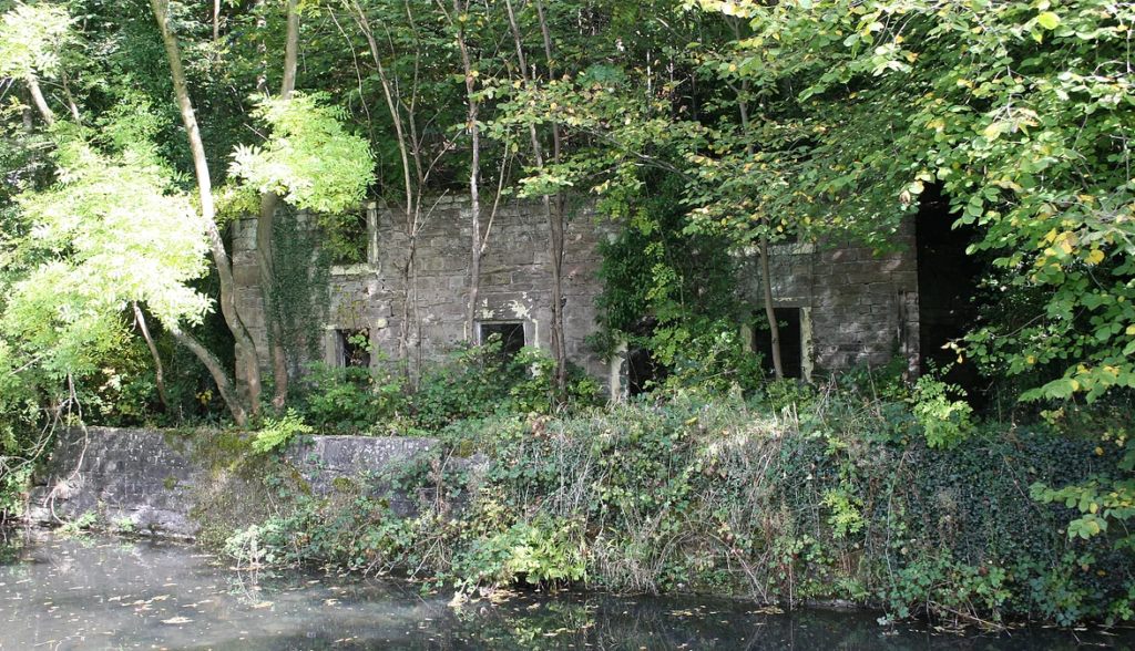
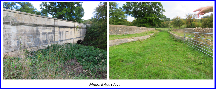
We now regained the towing path of the filled in canal and followed it through to Midford where we had to make another slight detour round the Weigh House which is surrounded by high fences and trees. This building housed a machine for weighing boats rather than using the usual gauging stick so that tolls could be charged.

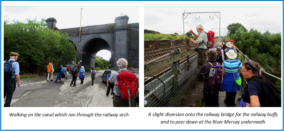
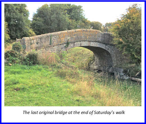
At Midford the Camerton and Limpley Stoke Railway cut across the canal with temporary lines having been laid on the towpath of the then derelict canal for moving materials to build the new railway. We carried on along the canal to Midford Aqueduct, the start of the Radstock Branch. where a canal was planned to transport coal from Radstock. This would have needed 19 locks and rather than continuing the canal a tramway was built with a canal basin across the other side of the aqueduct. The aqueduct was in poor condition and has been restored with the aid of Heritage Lottery funding.

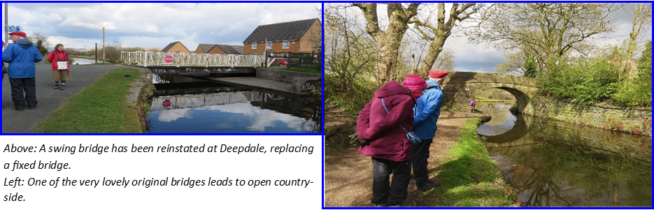
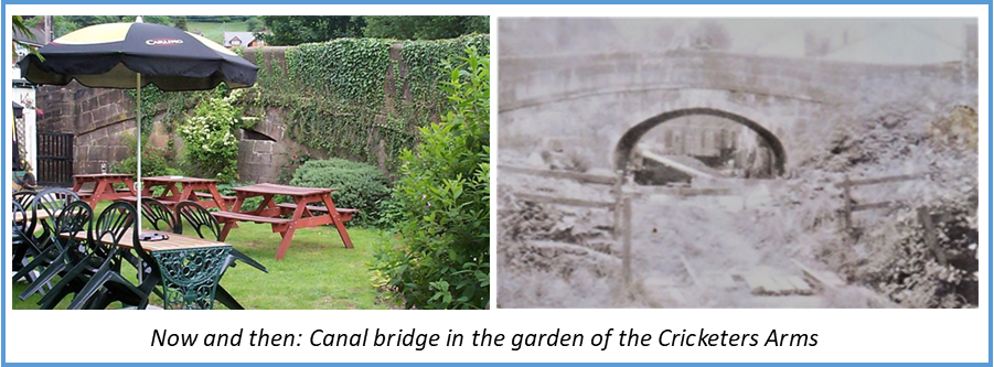
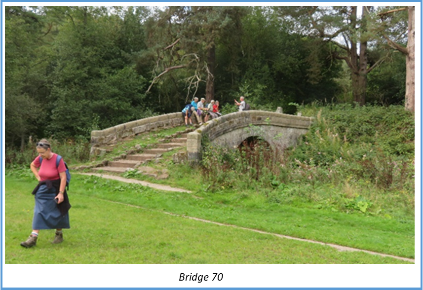
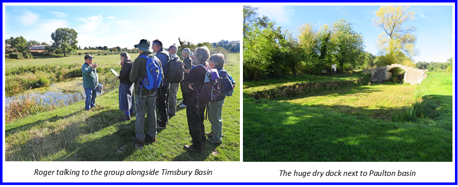
A short way from here is the last surviving original bridge on the canal. This was the final stop for the day from where we retraced our steps to the car park.

Then followed an enjoyable evening at the Swan Hotel in Bradford on Avon. With a choice of classic British and Thai dishes the food was delicious.

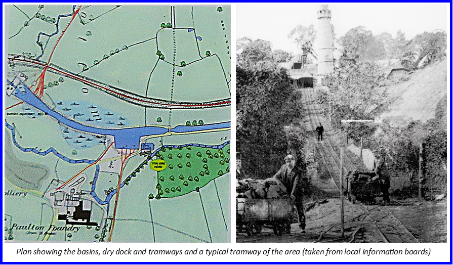
On Sunday morning Derrick along with Roger Halse met as at Paulton and took us down to Paulton and Timsbury Basins, access to which is down a lane and across a field.

Being used to terminal basins in towns and cities surrounded or obliterated by buildings it was unusual to see these basins in the middle of a field. The few buildings that stood alongside the basins are long gone but in one of the fields you can make out dark patches where the various tramways would have brought coal down to the basin from the coal pits. There was also a very large dry dock. Both the basins and the dry dock have been excavated by the society with the approval of the landowner and the basins are in water.

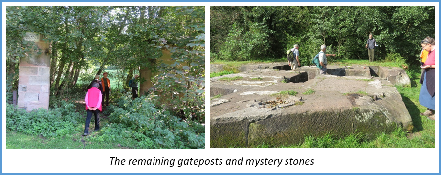
A short way from the basins there is a bund a cross the canal to retain the water as the next bridge needs rebuilding. This is a public right of way and the society are keen to restore it but currently there are problems to overcome with the landowner. We walked a little further along past the site of a stop gate to Withy Mills where there had been another colliery, tramway and a large wall is visible which had been the wharf for the colliery.

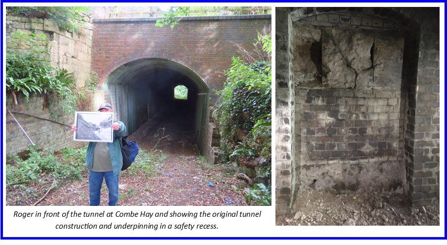
Returning to our cars we drove to Combe Hay for the afternoon’s walk. We started at a crossroads, not realising at first that there was a tunnel directly underneath. This had originally been a canal tunnel then was converted to a railway tunnel (now disused) by lowering the invert, underpinning the walls and building new walls and roof.

We then headed to the top of Combe Hay locks access and this is where things get compilated with the alterations that were made to negotiate the change in level.

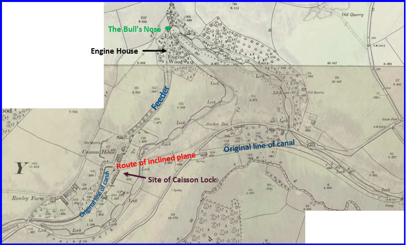
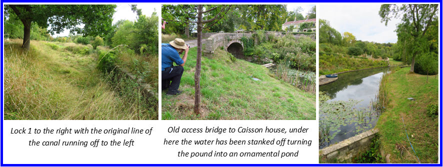
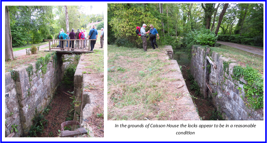
 The locks 1- 15 all survive, some in reasonable condition some with erosion to the soft local stone, the top locks and site of the engine house are on the land of Caisson House, the owners of which had kindly given permission for us to view. The line of the locks passes in front of the house with the feeder and original canal running to the rear.

A Boulton & Watt pumping Engine fed the summit pound, the base of the engine house can just be made out in the undergrowth of Engine Wood.

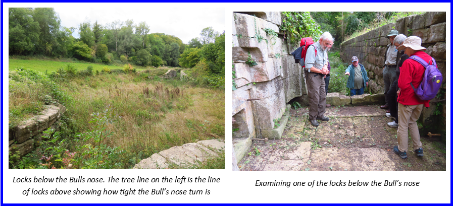
At the Bull’s Nose – an extremely tight bend between locks 10 and 11 the canal leaves private land and a public footpath runs at the side down the side of the locks through the woods.

Reaching the road, lock 16 has been lost underneath a former railway embankment and after crossing the road the canal runs under the drive of a house. Beyond here apparently the locks are not in very good condition but we left the canal at this point as we’d run out of time. We returned through the village to our cars, the end of a very enjoyable and extremely interesting weekend. Set in beautiful countryside it’s easy to see how popular the restored canal would be to cruise. It is a long term project but the society are doing well in building relationships with landowners and protecting the line for future generations.

A huge thank you goes to all those involved, for the welcome we received and the wealth of information and knowledge imparted: Derrick for all his organisation and support, Patrick for the talk, Liz and Roger for being our guides. Also to Julian and his team and Neil at Claverton Pumping station.

August Walk: In search of the Runcorn and Latchford Canal

The Runcorn and Latchford Canal, also known as the Old Quay Canal and the Black Bear Canal was part of the Mersey and Irwell Navigation. It was first proposed in 1660 that the rivers Mersey and Irwell should be made navigable from Manchester to Liverpool. But it wasn’t until 1720 that the necessary bills were tabled  ‘to scour and cleanse the rivers, and to make the necessary cuts and branches, build bridges, sluices, locks and weirs’ starting in the ‘town’ of Manchester, at 93¼ feet above sea level. 

The rivers took a very sinuous course so ‘cuts of considerable dimensions’ were built to bypass both the meanderings of the river and its tidal nature. Priestley stated “when their expansive works near Runcorn Gap are completed this navigation will be one of the first importance”.

Work began in 1727 and by 1737 boats ‘of considerable size’ or a small ship’ could make the journey from quays in Water Street, Manchester. A small ship of this time appears to be 75+ feet in length carrying 60-70 tons.

Riverside mills were a constant cause of conflict for the navigation. Often vessels became grounded because water levels at weirs had been lowered so much and legal action was regularly taken against mill owners to correct the problem. But the main difficulty for the navigation was the tidal section of the River Mersey between Warrington and Runcorn which had constantly shifting mudbanks and treacherous currents.

The solution was to build the Runcorn and Latchford canal. Completed in 1804, it was approximately 7 miles (11 km) long. It locked out of the River Mersey at Latchford and back into it at Runcorn Gap.  An aqueduct was built from Wollston cut to replace water lost from the locks that were used at each end to raise boats into the new canal section. At its terminus a dock was built which became part of the Port of Runcorn.

In the meantime the Manchester to Runcorn section of the Bridgewater Canal had been built (1776) and the canals were great rivals. Each company would offer reduced charges or special rates and concessions to entice traffic away from the other. Probably the most important cargo carried was raw cotton from Liverpool to Manchester, but timber, dyewoods, pig iron, lead, copper, nails, tar, sand, grain and flour were all carried. It was a common site to see flats piled high with cotton bales – making it difficult for the steerer to see where he was going.

The Runcorn and Latchford rather belatedly started passenger carrying in 1807 (the Bridgewater had been doing this for some years). But in 1830 the Liverpool and Manchester railway opened and the decline started.  In 1844 the Runcorn and Latchford was bought out by the Bridgewater Canal Company for £550,800 – a huge amount at the time. They neglected it so its condition deteriorated. In 1882 it was described as being ‘hopelessly choked with silt and filth’ and was open to 50 ton boats for only 47 out of 331 working days.

It had now become cheaper to import goods via Hull, hence the proposal to build the Manchester Ship Canal. The Bridgewater Canal Company was bought out by the Manchester Ship Canal Company in the 1880’s as they wanted to use part of the course of the Runcorn and Latchford for their route. The excavation of the Manchester Ship Canal ploughed through most of the Runcorn end of the Runcorn and Latchford Canal, especially its lock system, so much of the western end of the canal including the docks disappeared.

The eastern end of the Runcorn and Latchford fared rather better, as the section between Twenty Steps Bridge and Latchford Lock was retained. A new lock, called Twenty Steps Lock, was built where the old canal left the course of the Ship Canal, this was used to supply tanneries at Howley with hides imported from Argentina, a trade which continued until the 1960s. This is the section known as the Black Bear Canal, after a local pub. It ceased to be used after the tanneries closed.

Our walk started at Moore Nature reserve car park, roughly midway along the route of the Runcorn and Latchford canal and we headed east towards the Latchford end of the canal.

After crossing the canal a couple of times because of the position of a wildlife lake we were soon walking along the towpath with the canal on our right in remarkably good condition, considering how long this stretch has been abandoned.  In many places the stone walls of the canal were clearly visible on both sides of the cut.

We emerged from the leafy towing path onto a road which runs on top of the line of the canal and under the Chester – Warrington line viaduct (originally the London and North Western) which spanned both the River Mersey and the canal. The viaduct provides a footpath over the River Mersey so we made a slight diversion onto it for a better view of the River Mersey and to listen to some railway history from Gerald. From here the canal ran for a short distance alongside a loop in the River Mersey.

We were soon off the road and back on the towing path with the canal on our right and the Mersey on our left. It was a surprise to see this stretch of canal in water with houses backing onto it. This next section, until we crossed the Manchester Ship Canal forms part of the Trans Pennine Trail.

We were now approaching the Manchester Ship Canal at one of the points where it cut into the Runcorn and Latchford and views of the canal were replaced by metal railings with trees and undergrowth beyond. Peering through them gave clues that we were approaching Walton lock. Walton lock was built to give access to the River Mersey from the Ship Canal and a small Warrington dock was built in anticipation of a good trade for Warrington but this was never popular and the dock and lock became derelict.

Following the footpath around the dock brought us out opposite an attractive row of victorian houses with an inscribed stone ‘Riverside View 1870’. Unfortunately for the occupants of the houses the riverside view didn’t last long as the course of the river was altered with the building of the Manchester Ship Canal.

The Transpennine Trail runs down the side of these houses and onto the northern edge of the Ship Canal. A short walk along here brought us to Twenty Steps Lock, the eastern section of the Runcorn and Latchford. The lock is infilled and can be viewed through railings from the side of the canal and from the Ship canal bridge above.

Although the section of canal from here to Latchford lock closed later than the rest of the Runcorn and Latchford the canal here has been infilled but remains a green corridor. A pleasant walk  but little to be seen apart from the remains of the locks at each end.

We now left the Runcorn and Latchford, crossed the Manchester Ship Canal, and headed straight down the main road to the London Bridge Inn on the Bridgewater Canal for a very welcome lunch. Then suitably refreshed we headed back towards Moore along a very pleasant stretch of the Bridgewater Canal.

Leaving the Bridgewater at Moore and walked along Moore Lane back towards the Nature Reserve. This took us back across the Chester – Warrington line and the Crewe – Warrington line. These were both raised during the construction of the Ship Canal to give a clear headroom of about 73’6” from normal water level. The Crewe line was diverted to achieve this rise and there is a tunnel under the road and an original road bridge over the line adjacent to the road bridge, the tunnel has been infilled but the portal is still clearly visible. We continued down Moore Lane and re-crossed the Manchester Ship Canal, taking us back to the car park.

Back at the car park some walkers had to leave but a number continued onto the optional extra loop. Heading west through the nature reserve this time it was about half a mile until we were standing in the bed of the Runcorn and Latchford Canal, the footpath runs down the middle of the canal bed and again stone walls were visible on both sides. This path took us back in the direction of the car park and the finish of the walk.

This was a varied and interesting walk but will probably be remembered for the competition as to who could pull out and destroy the largest piece of Himalayan Balsam and for the large amounts of really awful insect bites that a good number of walkers suffered afterwards. In this respect a hot, dry August day was probably not the best scheduling!

Many thanks to Beth for recce-ing and leading the walk (and for the antihistamines!) and to Gerald for all the extra canal and railway information.

Next time out: Weekend Away. The Somerset Coal Canal, evening of 23rd –25th  September.

IN SEARCH OF THE RUNCORN AND LATCHFORD CANAL

SATURDAY 6th AUGUST 2022 10a.m. start

Anyone who was able to join us for the Uttoxeter canal walk last year will have a good idea what to expect here! The Runcorn and Latchford canal was dissected by building of the Manchester Ship canal and only part of it was able to continue trading, but surprisingly bits of it still remain.

This is a circular walk starting and finishing at Moore Nature Reserve. The morning walk of 3 miles follows the remains of the Runcorn and Latchford canal, mainly on the reserve, finishing at a canalside hostelry serving J W Lees beers. We then return to the nature reserve on a pleasant stretch of the Bridgewater between Stockton Heath and Moore, a further 3 miles. There will also be parts of the Manchester Ship canal to be seen as it runs between the two canals. There is an optional short loop at the end of the walk with more remains of the Runcorn and Latchford. 

Meet at 10 a.m. Moore Nature Reserve Car Park,  Lapwing Lane, Penketh, Cheshire, Warrington WA4 6XE. What 3 Words:  song.shady.headed, grid ref:  588855.

The lunch stop is pretty much the half way point of the walk at The London Bridge Inn, Stockton Heath:

https://www.londonbridgeinn.co.uk/eat

Pre-orders are required so if you wish to eat at the pub please let us have your order by Friday 29th July. Otherwise e-mail or ring/text by Friday 5th August .janandvernbrown@gmail.com /07443834997

THE PHOENIX ARISES. LAPAL CANAL WALK

Opening in 1798 the Dudley No 2 Canal was built to avoid going through Birmingham and having to pay tolls. It ran from the Dudley No 1 Canal at Parkhead to the Worcester & Birmingham Canal at Selly Oak. 11 miles in length it cut through the hills rather than locking over, giving two tunnels, the 563 yard long Gosty Hill tunnel and the 2.2 mile long Lapal tunnel. The Lapal tunnel was initially worked by legging, which could take up to four hours. Later a pumping engine was installed at the Halesowen end of the tunnel, pumping water over a stop plank to flush boats through. This allowed the tunnel to operate in three hourly slots from alternate ends, the first being at 4 a.m. and the last at 10 p.m. indicating that the canal must have been pretty busy. However, there were regular problems with the straight sided tunnel and it was frequently closed for repairs. When the tunnel was finally closed in 1917 the original width of 9’ had reduced to 7’ 9 “ and the height reduced to 6’. Andy Tidy’s YouTube video explains it well:

The west end of the canal is still navigabale from Parkhead to Windmill End, through Gosty Hill tunnel to Hawne Basin. The Lapal Canal Trust was founded in 1990 to conserve and restore the five and a half miles from Hawne Basin to Selly Oak.  Restoration has started on the ‘lost’ section of the canal but the Lapal tunnel is beyond repair. To rejoin the two ends of the canal would mean taking an alternative route and entail building several locks (more on this later)

Hugh Humphreys, Simon Dearn and Dave Pearson from the Trust kindly agreed to be guides for our walk and provided a wealth of information about the canal, the current restoration and future aims of the Trust. We met at Selly Oak where restoration work has started on the two mile section to California, the eastern end of Lapal tunnel.

A student accommodation building and subsequently Selly Oak shopping centre have been built over the original junction with the Worcester & Birmingham canal but the canal has been diverted to the edge of the development where a concrete channel has already been built as part of the redevelopment programme.

Almost completed, when we visited, is a widening on the opposite side of the Worcester & Birmingham canal to allow boats to turn into the entrance of the Dudley No 2. The junction itself presents difficulties as there is currently a gas main and fibre optic cable running through it. These will need to be lowered below canal bed level. The quote for the gas main alone is a staggering £800k. There is funding of £724k available from the development agreement but this has to be commenced by 2025, so there is pressure to get this first part restored quickly in order to release the money. A swing bridge also needs installing at the junction.

Beyond the concrete channel the line of the canal is obvious and just needs excavating but there are two very narrow sections where the corners of a retailer’s car park and land owned by Homebase jut out into the channel. Both have agreed to these corners being removed.

The canal soon meets Harbourne Lane, a very busy road. A bridge with concrete channel under has been built but is not yet accessible as the towpaths have not been filled in. It also has to have lighting installed as it is classed as a tunnel.

On the other side of the road is Harbourne Wharf Basin, which is in water having been excavated in 2015, this will be the end of the first stage of the restoration.

Just beyond here Selly Oak bridge is the only remaining brick arch bridge on the canal and contender for the oldest bridge on the BCN. The towpath used to continue on this side of the canal but this bridge will become a turnover bridge with the towpath running along the edge of Selly Oak park. In 2016 and 2017 WRG volunteers repaired the canal side wall leading up to the bridge and this summer will be returning to construct a wheelchair accessible path from the bridge down to the towpath.

The next section of the canal is the fairly typical muddy ditch complete with trees and undergrowth. Three new bridges will have to be installed along here: a replica drawbridge, a new fixed bridge and a swing bridge. A little further along the canal crosses Bourne Brook on a fixed bridge, there was originally a small aqueduct here, another obstacle for the Trust.

Soon after this the canal passes alongside Weoley Castle , the remains of a moated manor house owned by Birmingham Museums

https://www.birminghammuseums.org.uk/weoley/about

which would provide a good place of interest for boaters on the restored canal.

We were now approaching California where a triple staircase lock is planned leading into a large marina and would initially be limit of navigation. The Eastern end of the Lapal tunnel was here, but there is now no sign of it. The site has also been used for landfill at one time. The plan is to redevelop the whole site for housing and the marina possibly with a boatyard business and hire base.

Our morning walk finished here. We shuffled cars to the Lighthouse pub, handily placed above the southern end of Gosty Hill tunnel, the very obliging landlady putting on a spread for us and allowing us to leave cars there for the afternoon.

We returned to the canal at the Gosty Hill tunnel portal where there are fascinating remains of Steward and Lloyds, the largest steel tube factory in England. Immediately after this the remains of ramps are visible, these were used the slip boats from a boatyard next to Steward and Lloyds.

We were now approaching Hawne Basin and the towpath stops as you reach Coombeswood Trust land. We detoured by road to the Trust’s gates to be given a guided tour of the basin. This was originally a transhipment basin for coal from Hawne Colliery, later for steel tubes from Steward and Lloyds. It now has leisure and residential moorings and boatyard facilities.

Just past the end of the basin the canal comes to a full stop. Beyond here the line of the canal is very overgrown. We retraced our steps to Coombs Bridge, crossed the canal and continued walking along a path on the other side. We soon reached the busy A458 which the canal has to cross but, being elevated, there is room to take the canal underneath.

Once across the road the canal runs on a high embankment alongside the delightful Leasowes Park which has Grade 1 listing of parks and gardens of historic interest. Here the channel has been rebuilt but unfortunately was done cheaply and doesn’t hold water properly.

The next obstacle is Manor Way, another substantial and busy road. The canal will have to be diverted here to cross lower down the hill where an aqueduct could be built. Across Manor Way is the western end of Lapal tunnel. For the canal to become a through route again it would have to divert to the north of the tunnel through Woodgate Valley Country Park. This would mean building several locks to traverse the hill and involve a major junction crossing.

Fully restored the Dudley No 2 canal would provide a great through route from the Stourbridge canal to the Worcester and Birmingham and another loop on the system.

Further information is available on the Trust’s website and facebook site:

www.lapal.org

www.facebook.com/lapalcanaltrust

Many thanks to Hugh, Simon and Dave for a guided walk full of interest and to Hugh for providing transport to return drivers to their cars. Much thanks also to Paul Niblett for his excellent organisation.

Next time out: Saturday 6th August.  In search of the Runcorn and Latchford Canal

The Phoenix Arises: The Lapal Canal

Walk – Saturday 11 June 2022. Start at 10.30am, finish by 4.00pm
Covering parts of the Dudley No2 canal – but certainly not its Lapal tunnel!

OS 139 Birmingham & Wolverhampton
(Old) Pathfinders 933/SO 88/98 Stourbridge & Kinver and 934/SP 08/18 Birmingham

Parking & start: Selly Oak Shopping Park (4 hrs free parking) – Sainsbury’s etc., in front of
Unite Students Battery Park on its canal side (the Worcester & Birmingham Canal, W&BC).
Grid reference: SP043828. What three words: drums.glue.field. Within view of Selly Oak rail station.

The Dudley No2, from Windmill End Junction at Netherton to the W&BC in Selly Oak, is only 8 miles long, just over 2 miles of which was the Lapal tunnel. We shall be walking a total of about five miles, in two sections:

• the full eastern part from the W&BC junction to the site of the eastern tunnel portal;
• part of the western section from near to the western tunnel portal to Gosty Hill tunnel,
incorporating the current end of navigation at Hawne Basin/Coombeswood.

As this is a linear route, some car shuffles will be necessary.

Though a relatively short walk, there is much to see such as the work done, and being done, at the W&BC end to facilitate a new junction. There is some canal still in water in Selly Oak park, Weoley Castle along the route, the Leasowes/Heywood embankment, Hawne Basin, the remains of the vast Stewarts & Lloyds tube works, Gosty Hill tunnel etc etc. Though lacking in the ever-illusory snuff mines, it’s still an area full of interest.

There are several societies involved with waterways in this area of the West Midlands and we are delighted to have a member of the Lapal Trust to accompany us. Lunch will be available at the Lighthouse pub at Old Hill (0121 537 70133). It has a spacious external picnic area. The landlady is willing to arrange a buffet comprising sandwiches, pie, quiche, chips etc, plus tea/coffee, at £7.50 per head. Please advise Paul by Tuesday 7th June if you wish to partake of this offer. Paul would also appreciate knowing the overall numbers attending so please let him know by Friday 10th if you plan to come (01782 641967).

The route is generally good, on well-established paths and pavements but, as always, stout
shoes etc.

Rochdale Canal Walk 2nd April 2022

Building of the Rochdale canal started in 1794 at Sowerby Bridge. It took a workforce of 500 navvies 10 years to build this 32 mile long canal which rises 350 feet through 36 locks to summit level then drops 435 feet through 56 locks into Manchester, making it the most heavily locked canal in the country.

This was the first transpennine canal to open and the only one with no tunnels as William Jessop did not trust the technology at that time. It was however considered to be the most difficult canal on which to work.

Being a wide canal the Rochdale was more successful than the Huddersfield Canal and became the main means of transport between Lancashire and Yorkshire with cotton, wool, coal, timber, salt, cement and grain dominating.

Although inevitably hit by railway competition, by cutting tolls the canal did manage to retain trade and remain profitable until the first world war but by 1920 the Rochdale was in financial trouble. Then in 1923, the Oldham and Rochdale Corporations Water Act paved the way for the transfer of its eight reservoirs to those corporations to supply drinking water. The last cargo of raw cotton arrived at Littleborough in 1929 and the last complete journey of the Rochdale took place in 1937. During the Second World War, barges were plucked from the canal and placed on its reservoir at Blackstone Edge in a cunning plan to stop Hitler landing water planes, their carcasses being found when the reservoir was recently drained.

 Closure was authorised in 1952, except for the 1½ miles at the Manchester end from Ashton Canal junction into Castlefield Basin, then in 1962 the canal was cut in two when the M62 was built.

An Act of Parliament was sought in 1965, to authorise the abandonment of the canal, which the Inland Waterways Association petitioned against. When it was finally passed, it contained a clause that ensured the owners would maintain it until the adjacent Ashton Canal was abandoned.  The Ashton Canal, which joins the canal above lock 84, reopened in 1974, and the nine locks on the Rochdale Canal to Castlefield basin were restored at that time.

The Rochdale Canal Society was formed to promote the restoration of the canal and in the 1980s and 1990s small scale work began to re-open stretches of the canal between Todmorden and Sowerby Bridge. This involved restoring bridges and locks to navigable condition. The Calderdale section of the canal reopened in the 1990s and the real celebrations began when lottery funding became available. Because it had stopped carrying traffic by the 1940s, the canal had not been nationalised and not filled in when it became derelict. This allowed ownership to pass to the Waterways Trust in 2000 and British Waterways were given the monumental task of restoring it to full use.

Funding of 23 million pounds was announced, mostly from the Millennium Commission and English Partnerships that would enable the remaining obstacles to be removed. It entailed refurbishing 24 locks, building 12 new road bridges, 50,000 cubic metres of dredging and building 900 metres of new canal channel. In July 2002 the canal re-opened, almost 200 years after its original opening.

Our walk was from Castleton to Littleborough where the many blockages were removed during this final period of restoration prior to re-opening, between 2001 and 2002. The M62 crossing just south Castleton seemed a good place to start.

No provision had been made for the canal when the motorway was built, however there was a farm access tunnel just to the side of it. As the motorway climbs steeply at this point there was enough height to take the canal through here with the farm access diverted. A public inquiry and a High Court ruling was needed before land could be compulsory purchased from two farmers.

The original lock 53 was replaced with a new lock south of the motorway to raise the canal to the level of the tunnel, the concrete was still drying when the canal was reopened on 1st July 2002.

 A towing path was needed here as there is no way for a walker to cross the M62 but as the tunnel is just wide enough for a wide beam boat a floating towing path was installed leaving enough space for a narrowboat but removable should a wide boat require access.

A few minutes walk took us into Castleton, a relatively modern town by British standards it is believed to date from the early 1700’s and until 1875 was known as Blue Pits, named after a local quarry which mined blue sand. Lock 51 here is named Blue Pit top lock. This lock had been in good condition and just needed cleaning, pointing and new gates fitting but Manchester Road bridge below the lock had been culverted and a brick retaining wall build blocking the canal.

There had been many blockages through Rochdale, the next one on our walk was Edinburgh Way, a major road where a large roundabout had completely blocked the route. The original plan was for the whole roundabout to be raised to allow a new 90 metre long tunnel to pass below. The plan was revised so that the roundabout was replaced by a signal-controlled junction, with a new channel for the canal and a shorter tunnel under the road.

The old route of the canal ran straight under Edinburgh Way. The new route runs to the left and the road system was altered to accommodate it.

There is no towing path through this section, signposts take walkers on a diversion round the roads with just a glimpse of the new cutting.

The next two bridges had been dropped and culverted needing excavating and reconstructing. Then  the canal passes what used to be the Sealocrete works which was built on the site of Dickon Green Cotton Mill. The factory had encroached onto the canal channel narrowing it to only a few feet across, too narrow for even a narrowboat passage. As part of the restoration work a new concrete channel was constructed, wide enough for passage of a wide beamed boat.

Next we reached the junction with Rochdale town arm, running for half a mile from Halfpenny Bridge  –  “a rare survival of a toll bridge over a canal” which is now grade II listed –  to Richard Street basin.

Warehouses once lined its banks but its intrusion into the town meant it was a prime target for redevelopment and it became one of the first parts of the canal to be filled in during the late 1960s. A retail shopping centre now covers most of the canal arm, with the former basin serving as the car park.

Back on the main line and through the turnover bridge are two locks, between these on the offside were Wellfield Cotton Mills and Wellfield Corn Mill, here another arm ran around and between the mills.

Early map showing the half mile Rochdale Arm with its wharves and on the main line between locks the arm running around Wellfield Cotton and Corn Mills.

The mills are long gone and have been replaced by housing with a road running over the line of the canal arm although the start of the arm still remains.

This was the half way point of the walk and soon after a short diversion took us to the Hornet for some very welcome food. The afternoon walk saw us leaving Rochdale and heading into countryside. There are a few more reinstated bridges between here and Littleborough, but also some elegant original stone bridges to admire complete with deep rope marks.

As snow started to fall we approached Clegg Hall which is supposedly haunted by a boggart. This 17th century hall replaced an earlier moated hall where legend has it that a wicked uncle killed his two nephews and then tried to kill his brother in order to gain the Hall and lands. The uncle got his comeuppance and is said to haunt the hall along with one of his nephews.

To one side of the Hall is an attractive row of weavers cottages and to the other side a small stone built mill which has been restored and converted to housing.

There had been two more bridges blocking the channel between here and Littleborough, Smithy Bridge and Ben Healy Bridge. Restoration of these bridges entailed closing and diverting roads and excavating huge amounts of rubble as well as diverting service pipes and cables. Ben Healy Bridge, at Littleborough is now the biggest bridge on the canal at 33 metres long. The road having been widened and angled across the canal, it has cut into an area that used to be a wharf which served Cleggs Wood Colliery where fire clay was extracted. Coking ovens were located at the side of the wharf, between the canal and the road but there is no longer any trace of these.

Left: Ben Healy Bridge, the Railway Hotel and the wharf for Cleggswood Colliery. There had previously been coke ovens here. Right: Ben Healy Bridge from the same spot today. The road has been widened and now sits at an angle over the canal, covering part of the old wharf area.
 

Just through the bridge we arrived at Littleborough Wharf and the end of our walk.  It had been a typical British spring day of sun and snow showers.

Next time out: Saturday 11th June. The Lapal Canal

Return to the Rochdale Canal

Saturday 2nd April 10 a.m. start

This walk will start at Castleton, take us through Rochdale and onto Littleborough – approximately 6 miles.

When the group last walked this section of the Rochdale in 1991 Littleborough was the head of navigation from the east. There were two major roads – at Castleton and in Rochdale – blocking the canal, and a factory had extended its land into the canal. Many bridges had been culverted and a few locks needed restoring.  During the morning we will be looking at the solutions to these problems starting at the M62 crossing at Castleton where there is a floating towpath. 

We will meet at 10 a.m. at The Canal Wharf, Canal Street, Littleborough. Postcode: OL15 0HA, What 3 Words: drop.snake.patrol, grid ref: 940163. Leaving a few cars here we will then drive to Castleton for the start of the walk. For those coming by train there is the option of joining the group at Littleborough or a little later at Castleton, however if you opt to join at Castleton it will entail an extra walk down the towpath to the M62 crossing.

The lunch stop is pretty much the half way point of the walk at The Hornet, a Hungry Horse pub:

https://www.hungryhorse.co.uk/pubs/greater-manchester/hornet/menu/main-menu

Pre-orders are not needed but the pub does want to know numbers in advance, so if you wish to eat there please let us know by Friday 25 March. Otherwise e-mail or ring/text by Friday 1st April:

janandvernbrown@gmail.com /07443834997

In the afternoon we leave Rochdale and head into the countryside, passing the historic grade two listed Clegg Hall and nearby weavers cottages to the end of the summit section of the canal.

Hope to see you there.

Jan and Vern.

Obituary: DAVE HANNAN

By Vern Brown

We have been saddened to hear of the recent death of Dave Hannan, a volunteer at Bugsworth Basin. He had been suffering with pancreatic cancer.

I met Dave at Bugsworth in about 2014. I wasn’t sure what to make of this bluff, opinionated guy, until we began working together. I think our first job was replacing the wooden fence above the end of the lower basin, I soon realised that here was a chap with a wealth of knowledge and the drive to put that knowledge into action. Dave became a mainstay of the maintenance team at the basin, always willing to help where he was needed, whether trimming brambles with Martin or rebuilding wash walls with me. His greatest contribution was in the building of the replica tramway wagon with his engineering knowledge, we would have struggled severely without him.

He will be missed by all the recent volunteers from the basin and by his many friends in Buxton Mountain Rescue, CAMRA and the lock volunteers at Marple. As you can see, a man who got on with life.

Uttoxeter Canal Walk 18th September 2021

The walk was planned to coincide with a Heritage Open Day run by The Caldon and Uttoxeter Canals Trust who would be showing visitors around Crumpwood Wier and have information about the restoration of the canal. A few days earlier the good news had come that a planning application at Froghall for a housing estate to be built over the start of the canal had been turned down on many counts, one of which is that it didn’t make provision for the future restoration of the canal.

The Uttoxeter Canal was short lived, having been something of a white elephant for the Trent and Mersey Canal Company. In 1795 the Commercial Canal had been proposed – a wide canal linking Ashby-de-la-Zouch in Leicestershire with the River Trent and canals in Cheshire and Newcastle-under-Lyme. If built this would have been a severe competitor to the Trent and Mersey Canal. After a period of conflict the Trent and Mersey’s powerful connections and a promise to widen their canal they won the battle in 1797, with a victory for the Froghall to Uttoxeter canal scheme.

The canal widening never happened and the narrow canal was finally opened in 1811 running for 13.25 miles from Froghall to Uttoxeter with 17 locks along its length. Operating at a loss it closed in 1849 after being sold to the North Staffordshire railway who built their line over much of the canal. Over 170 years later it is amazing that there is anything left of the canal.

The Churnet Valley Railway line now runs from Leek Brook to Froghall with the line laid as far as Oakamoor sand sidings at the north end of Oakamoor village.

Our walk started in Oakamoor. Having parked in the station car park we started by looking at the remains of the railway. The railway didn’t follow the line of the canal through Oakamoor but went around it which necessitated building at tunnel. Several tunnels had to be built for the railway where the river course was hostile At 462 yards Oakamoor tunnel was the longest, it was also the wettest creating endless maintenance problems during its use. At the station side of the tunnel is a road crossing, the original crossing keeper’s cottage is now a holiday home and the current residents kindly showed us historic photos from the cottage.

From here we cut across to Oakamoor Picnic Site, now a pleasantly green site with the River Churnet running through but which had been the site of Oakamoor copper works. Oakamoor had been a site of metal working for some 800 years. In 1790 copper smelting began, mostly for factories in Birmingham. The business was bought in 1852 by Thomas Bolton and Sons, production continuing on the site until closure in 1962, after which the works were demolished. The factory was served first by the canal and then by an arm from the railway.

All that remains of the factory now are two gate posts and some seriously large stones, presumably bases for machinery and/or cranes, we spent some time puzzling over these – although there are several historical information boards around Oakamoor there is no mention of these stones.

In the centre of Oakamoor is the Cricketers Arms where we saw the first trace of the canal. The canal ran through what is now the pub’s garden (the pub predates the canal) and under the main road. The bridge is filled in but still intact.

With the bridge as a starting point we could now follow the line of the canal through the recreation area to Oakamoor station where the platforms survive.

From here we followed the track bed of the railway for a couple of miles to Alton, the Churnet Valley railway also wish to reinstate the line from Oakamoor sands to Alton which could provide the opportunity of a restoration partnership. This stretch is undeveloped and a popular walking and cycling route, making restoration look relatively easy. However underground are large gas, electric and sewage mains, it would be prohibitively expensive to divert or re-lay the 11kV cable which follows the line of the canal so it would be necessary to construct the canal adjacent to the cable, moving it only where required. The canal would have to continue on the north east side of the railway so cuttings and a couple of locks would be needed.

This was a very pleasant stretch through peaceful and pretty countryside, the railway of course ran straight and loops of canal remain on each side.

The morning walk finished at Alton station which has survived and is a Landmark Trust holiday home. We diverted at this point to visit the Talbot Inn for lunch. This proved a delightful place for a break, with large gardens at the side of the river, excellent food, beer, ice cream and service were appreciated by all.

Replete we returned to the station for the afternoon walk. Immediately after the station is Alton tunnel which took the track under the main road. This replaced a smaller canal tunnel which had a slightly different alignment to the railway tunnel but was about the same length.

From here to Denstone is the easiest section to restore as the canal is mostly still there. Significant clearing, dredging and probably re-lining would be needed which could be undertaken by volunteers and a new lock would be needed at the Alton end.

Soon after leaving Alton we were able to leave the railway bed to walk along the towing path which we followed most of the way to Crumpwood weir. The first section to Alton spill weir felt most like walking through forest but the towing path is clear. An intrepid group of walkers braved the undergrowth in search of locks.

Bridge 70 is the only complete original bridge on the canal. Built around 1810 it was saved from collapse by volunteers who restored it between 2012 & 2106. The original wooden rubbing strake is still attached.

And so onward past Carrington’s lock, which dropped boats down to river level, to the star of the show – Crumpwood weir – where the CUCT had a stall with information boards and Alison Smedley gave us a guided tour around this unique feature.

First we passed the Crumpwood Ram Pump House, a very unusual and possibly unique waterworks this was built between 1922 and 1928 to supply the Uttoxeter area with fresh water from nearby springs.

It’s unusual in that the pumps were powered by water turbines, using the head provided by an adjacent weir. There are 3 x 11 hp turbines made by Gilbert Gilkes & Co., each working a set of triple ram pumps, which had a combined output of about 15,000 gallons/hour under favourable conditions.

The pumphouse closed in the late 1970’s/1980 due to increased episodes of pollution in the supply but the pumps are still in place inside. It has recently been modified to allow fish to bypass the weir and get further up the river. Originally the environment agency wanted to get rid of the weir which would have seriously affected the canal restoration and destroyed a the unique structure so this alternative solution was found.

Crumpwood Weir is now protected with a grade II listing being the only structure of it’s type in the world. It was constructed within the River Churnet between 1807 and 1811 as part of the construction of the canal.  

Alison led us across the river on a modern bridge not normally open to the public, the original bridge was further up river leading straight from the towpath of the canal.

The weir is about 30 metres long with a vertical drop of 1.5 metres. At the Denstone end of the weir is the flood lock which has an impressive stone abutment on the weir side with architectural embellishment. Within the abutment at each end of the weir are two large sluices to allow the area behind the weir to be drained in times of low water level for the removal of silt.

The flood lock had double sets of gates that could be closed if the river level was too high or low although they were normally left open.

The canal continued into Denstone but as can be seen there is currently no path to follow so we returned to the railway bed for the final part of the walk into Denstone. Once again there were glimpses of canal bed alongside the path.

In Denstone the railway bed and station platforms still remain but the canal has been lost. The railway and canal took slightly different routes here, the railway having been built about 30 yards to the west of the canal. As this section of the canal was not needed by the railway it was sold and All Saints Church was built on the site.

Proposed restoration is for the canal to run to the east of Denstone, close to the river, necessitating the building of two new locks. This would be the start of a new route into Uttoxeter as the original line is built over there too.

This was the end of our walk and the last walk for this year. We hope to have a full programme of walks for next year and be able to start again in April.

August Walk – The Cromford Canal

Sunday’s walk started with rain and the owner of the burger van in the large public layby on the A6 where we met threatening to report us for using ‘her car park’. We set off undeterred pleased to be walking together again. We joined the canal at Chase Bridge, roughly half way between Ambergate and Whatstandwell, this section is owned by Derbyshire County Council and is an SSSI.

Steve Carver met us at Sims Bridge, this is where stone would have been taken across the canal from Dukes quarries to the Midland Railway. Steve firstly showed us some stones that had recently been uncovered between the canal and railway which were possibly the base of a crane for loading stone onto rail wagons, the 1900 OS map shows a siding at this point.

Steve Carver meeting the group Recently uncovered stone
1880’s map of the area

We crossed Sims Bridge to a cleared concrete floored area which was a three bay stable, possibly with an adjoining smithy, and then to a cleared area between the track from Dukes Quarry and the canal. Here was a large stone with a depression in the centre, reminiscent of a crane base except for an iron staple in the centre of the depression. Was this a crane base or one of a number of stones used to tether a Jib Crane?

The stable remains
The crane base

On entering the garden of Steve’s house there is a stone wall lined pit, similar to a water wheel pit, with a small cascade of water from the natural stream. This is thought to have once powered a water turbine to drive the saw mill and provide electric power. The water from the Ridgeway Sough (draining Wakebridge and Crich lead mines) may have also been used to supplement this. The original sawmill was a little way up the hill, originally powered by a water wheel and at some time destroyed by fire. The outfall from the pit passes under the canal in a culvert and discharges into the River Derwent.

The amazing ‘water feature’ in Steve’s garden

Retracing our steps to Sims Bridge we headed for Leawood Pumphouse. The canal runs through countryside here with wooded hillside to one side and views across the valley on the other – admittedly easier to enjoy on a dry sunny day! The canal goes through the 76 yard long Gregory tunnel and then over the railway on an aqueduct which is a Scheduled Ancient Monument. It has a cast iron trough supported by wrought iron cross members and dates from the 1840’s.

The portal of Gregory tunnel and cast iron aqueduct over the Midland railway

The first group who were due to see Leawood Pumphouse in steam dashed along to get there for 12pm only to find it wasn’t actually in steam – the message hadn’t reached us that the volunteers had not been able to finish the boiler testing work in time and are now hoping to be back in steam for the August bank holiday. However, we were given an excellent tour by a very knowledgeable guide.

Crossing High Peak aqueduct to Leawood Pumphouse and our wonderful guide in front of the boilers

The original iron boilers from 1849 had to be warmed up slowly which was very inefficient in both coal and labour so in 1900 they were replaced with two locomotive type boilers.

We stopped for lunch at High Peak Workshops at the foot of the Sheep Pasture incline of the Cromford and High Peak Railway, opened in 1831 to connect the Cromford Canal to the Peak Forest Canal at Whaley Bridge and originally intended to be a canal route. It was constructed on the same principle as a canal with long level sections (originally worked by horses) connected by inclines where the wagons were raised and lowered on ropes, with the aid of stationary steam engines. The following film shows the Sheep Pasture incline and winding house and a journey over parts of the line (footage from 6.30 minutes – 12.15).

A rather wet lunchtime at High Peak junction

We then headed for the Leawood or Nightingale Arm. Opened in 1802 it originally ran for about 800 yards into Leawood but in 1819 (after complaints about water ‘abuses’ by Mill owners) its length was halved, the terminus then being Peter Nightingale’s hat factory.

At the junction with the main line is Aqueduct cottage built as a lock keepers’ cottage for the stop lock/water control gates at the junction. The cottage was lived in until the 1960’s, then became and bunkhouse for a walking group, but later fell into disrepair. However, the Friends of Aqueduct Cottage and Derbyshire Wildlife Trust, who own the cottage and woodland behind it, are now restoring it. When finished it will house a Visitor Interpretation Centre.

Looking along High Peak aqueduct to Aqueduct cottage at the entrance to the Leawood Arm – the exterior has been restored and the lime mortar is currently being left to dry out
Aqueduct cottage before restoration

The ‘stop lock’ outside the cottage is still something of a puzzle. Boats weren’t allowed through unless the level of the water in the Arm was higher than the main line. The lock is 70’ long, there are two gate recesses at the junction end but nothing at the other end, however a map of 1811 shows a conventional lock. The lock wasn’t in use for long so whether the Leawood end of the lock was removed or the map was incorrect is unknown.

There is still some water in the first section of the branch until it crosses the Midland railway, there was a cast iron aqueduct here clad in decorative stone, now there is a pedestrian bridge built across.  The wharfingers house still stands (now extended and a private dwelling) and stone sets and crane base are still in situ.

After returning to the junction and crossing High Peak aqueduct for the third time that day the heavens opened, necessitating sheltering under a High Peak railway canopy for a while until the worst passed. It was then a fairly quick walk to Cromford Wharf. It was good to see Birdswood on the move – not horse drawn currently though and unable to go all the way to Leawood Pumphouse due to a problem with the swing bridge.

Heading towards Cromford Wharf alongside Birdswood

Most of the group know Cromford Wharf fairly well so we didn’t spend much time here, dispersing to train, bus and car shuttles fairly quickly where we could dry off, but a good day was had by all. A huge thanks goes to Steve for his brilliant guided tour and also to Hugh Potter who met with us on the canal a few weeks ago and provided us with much information (I’m sure we forgot some of it but we did our best!).

Steve has subsequently asked us to put out an appeal for volunteers to help with clearing reeds come the autumn. We have his contact details should anyone local be able to help out.

Next time out: Saturday 18th September Uttoxeter Canal